Category Archives: Climate Change

Mapping Resources

Land Cover and Surface Climate Group in the Department of Earth and Environment at Boston University
http://www.bu.edu/lcsc/data-documentation/

ORNL’s LandScan™ is the community standard for global population distribution
http://www.ornl.gov/sci/landscan/

MCD12Q1_Global_crop

Shifts in global water systems — markers of a new geological epoch: The Anthropocene

Source: http://www.eurekalert.org/pub_releases/2013-05/gwsp-sig051413.php

Contact: Terry Collins
tc@tca.tc
416-538-8712

Contact: Alma van der Veen
49-228-731846
aveen@uni-bonn.de
Global Water System Project 

Shifts in global water systems — markers of a new geological epoch: The Anthropocene

Experts in Bonn to detail how science can help people mitigate or adapt to major global human-induced water system changes

 IMAGE: This is an image of North America from the data visualization video “Water in the Anthropocene, ” to debut May 21 at gwsp.org andwww.anthropocene.info….

Click here for more information. 

A suite of disquieting global phenomena have given rise to the “Anthropocene,” a term coined for a new geologic epoch characterized by humanity’s growing dominance of the Earth’s environment and a planetary transformation as profound as the last epoch-defining event — the retreat of the glaciers 11,500 years ago.

And in Bonn, Germany May 21-24, world experts will experts will focus on how to mitigate key factors contributing to extreme damage to the global water system being caused while adapting to the new reality.

“The list of human activities and their impact on the water systems of Planet Earth is long and important,” Anik Bhaduri, Executive Officer of the Global Water System Project (GWSP).

“We have altered the Earth’s climatology and chemistry, its snow cover, permafrost, sea and glacial ice extent and ocean volume—all fundamental elements of the hydrological cycle. We have accelerated major processes like erosion, applied massive quantities of nitrogen that leaks from soil to ground and surface waters and, sometimes, literally siphoned all water from rivers, emptying them for human uses before they reach the ocean. We have diverted vast amounts of freshwater to harness fossil energy, dammed major waterways, and destroyed aquatic ecosystems.”

“The idea of the Anthropocene underscores the point that human activities and their impacts have global significance for the future of all living species — ours included. Humans are changing the character of the world water system in significant ways with inadequate knowledge of the system and the consequences of changes being imposed. From a research position, human-water interactions must be viewed as a continuum and a coupled system, requiring interdisciplinary inquiry like that which has characterized the GWSP since its inception.”

Among many examples of humanity’s oversized imprint on the world, cited in a paper by James Syvitski, Chair of the International Geosphere-Biosphere Programme and three fellow experts (in full: http://bit.ly/Yx4COp), and in a new “Water in the Anthropocene” video to debut in Bonn May 21 (available at gwsp.org and http://www.anthropocene.info):


  • Humanity uses an area the size of South America to grow its crops and an area the size of Africa for raising livestock
  • Due to groundwater and hydrocarbon pumping in low lying coastal areas, two-thirds of major river deltas are sinking, some of them at a rate four times faster on average than global sea level is rising
  • More rock and sediment is now moved by human activities such as shoreline in-filling, damming and mining than by the natural erosive forces of ice, wind and water combined
  • Many river floods today have links to human activities, including the Indus flood of 2010 (which killed 2,000 people), and the Bangkok flood of 2011 (815 deaths)
  • On average, humanity has built one large dam every day for the last 130 years. Tens of thousands of large dams now distort natural river flows to which ecosystems and aquatic life adapted over millennia
  • Drainage of wetlands destroys their capacity to ease floods—a free service of nature expensive to replace
  • Evaporation from poorly-managed irrigation renders many of the world’s rivers dry — no water, no life. And so, little by little, tens of thousands of species edge closer to extinction every day. 
 IMAGE: This is an image of Africa from the data visualization video “Water in the Anthropocene, ” to debut May 21 at gwsp.org andwww.anthropocene.info….

Click here for more information. 

Needed: Better water system monitoring and governance

The water community stresses that concern now extends far beyond ‘classic’ drinking water and sanitation issues and includes water quality and quantity for ecosystems at all scales.

Says GWSP co-chair Claudia Pahl-Wostl: “The fact is, as world water problems worsen, we lack adequate efforts to monitor the availability, condition and use of water — a situation presenting extreme long term cost and danger.”

“Human water security is often achieved in the short term at the expense of the environment with harmful long-term implications. The problems are largely caused by governance failure and a lack of systemic thinking in both developed and developing countries. Economic development without concomitant institutional development will lead to greater water insecurity in the long-term. Global leadership is required to deal with the water challenges of the 21st century.”

“Humanity changes the way water moves around the globe like never before, causing dramatic harm,” says Bonn conference keynote speaker Joe Alcamo, Chief Scientist of the UN Environment Programme and former co-chair of the GWSP. “By diverting freshwater for agricultural, industrial and municipal use, for example, our coastal wetlands receive less and less, and often polluted, freshwater. The results include decreased inland and coastal biodiversity, increased coastal salinity and temperature, and contaminated agricultural soils and agricultural runoff.”

Adds Charles Vörösmarty, co-Chair and a founding member of the GWSP, which receives input from more hundreds of international scientists: “By throwing concrete, pipes, pumps, and chemicals at our water problems, to the tune of a half-trillion dollars a year, we’ve produced a technological curtain separating clean water flowing from our pipes and the highly-stressed natural waters that sit in the background. We treat symptoms of environmental abuse rather than underlying causes. Thus, problems continue to mount in the background, yet the public is largely unaware of this reality or its growing costs.”

Aims of the Bonn meeting

Featuring 60 special topic sessions, “Water in the Anthropocene” is a capstone event for the GWSP, which is developing “Future Water,” the water-related component of the emerging new multi-dimensional international collaborative environmental research framework, Future Earth.

A goal of the meeting is to synthesize major global water research achievements in the last decade and help assembling the scientific foundations to articulate a common vision of Earth’s water future.

It will recommended priorities for decision makers in the areas of earth system science and water resources governance and management.

And it will constitute a scientific prelude to October’s Budapest Water Summit, a major objective of which is to elevate the importance of water issues within the UN General Assembly negotiations on the Sustainable Development Goals — a set of globally-agreed future objectives to succeed the UN Millennium Development Goals in 2015.

 IMAGE: This is an image of Europe from the data visualization video “Water in the Anthropocene, ” to debut May 21 at gwsp.org andwww.anthropocene.info….

Click here for more information. 

Observers expect adoption of “water security” as a Sustainable Development Goal

Water expert Janos Bogardi, Senior Advisor to GWSP, says the absence of defined global water quantity and quality standards for personal use, agriculture and healthy ecosystems are critical gaps as the world community develops its next set of shared medium-term objectives.

“These definitions constitute a cardinal challenge today for scientists and politicians alike. It is important to reach consensus in order to make progress on the increasingly important notion of ‘water security’,” says Dr. Bogardi, stressing that changing terminology will not in itself solve problems. “Replacing the word ‘sustainability’ with ‘security’ is not a panacea.”

With respect to quantity, less than 20 liters daily for sanitary needs and drinking is deemed “water misery” while 40 to 80 liters is considered “comfortable.” (Current US per capita average daily consumption is over 300 liters; daily usage in urban Germany is about 120 liters per capita and in urban Hungary, where water is relatively expensive, the figure is 80 liters.)

Missing also are authoritative scientific determinations of how much water can be drawn without crossing a “tipping point” threshold into ecosystem collapse. While there is no general rule, GWSP scientists say withdrawals of 30% to 40% of a renewable freshwater resource constitutes “extreme” water stress, but underline scope to continue satisfying needs if water is returned and recycled in good quality. Mining fossil groundwater resources is by definition non-sustainable.

The GWSP is developing water quality guidelines for people, agriculture and ecosystems in the context of the Sustainable Development Goals.

“The urgency of formulating the post-2015 Sustainable Development Goals and a tracking system for their success means that quite soon the SDG negotiators must offer-up water targets,” says Dr. Vörösmarty. “Whether they focus predominantly on continuing the Millennium Development Goals (narrowly on drinking water and sanitation for human health) or formulate a more comprehensive agenda that simultaneously optimizes water security for humans as well as for nature remains an open question. The water sciences community stands ready to take on this challenge. Are the the decision makers?”

Definitions of water security

In 2007, World Bank expert David Grey and Claudia Sadoff of IUCN, defined water security as “The availability of an acceptable quantity and quality of water for health, livelihoods, ecosystems and production, coupled with an acceptable level of water-related risks to people, environments and economies.”

Their use of the term “acceptable” acknowledges that water security has relative, negotiable meanings.

In March, another formulation was set out by UN-Water, the United Nations’ inter-agency coordination mechanism for all water-related issues.

It defined water security as: “The capacity of a population to safeguard sustainable access to adequate quantities of and acceptable quality water for sustaining livelihoods, human well-being, and socio-economic development, for ensuring protection against water-borne pollution and water-related disasters, and for preserving ecosystems in a climate of peace and political stability.” (seehttp://bit.ly/1864vMG)

About the Global Water System Project (gwsp.org)

The Global Water System Project seeks to answer the fundamental, multi-faceted question: How are humans changing the global water cycle, the associated biogeochemical cycles, and the biological components of the global water system and what are the social feedbacks arising from these changes?

GWSP Core Themes:

1. What are the magnitudes of anthropogenic and environmental changes in the global water system and what are the key mechanisms by which they are induced?

2. What are the main linkages and feedbacks within the earth system arising from changes in the global water system? How resilient and adaptable is the global water system to change, and what are sustainable water management strategies?

GWSP gratefully acknowledges support of its activities provided by the four Global Environmental Change programmes of the International Council for Science — DIVERSITAS, International Human Dimension Programme on Global Environmental Change (IHDP), International Geosphere-Biosphere Programme (IGBP), World Climate Research Programme (WCRP) and the Earth System Science Partnership (ESSP) — and by national and international research funding agencies. The GWSP International Project Office received decade-long support from the Ministry of Education and Research of the Federal Republic of Germany (BMBF).

Mekong Adaptation and Resilience to Climate Change Report

Mekong ARCC Draft Final Report of CCIA Study
26 March 2013
Author: Mekong ARCC
The Mekong ARCC Climate Study Team has released the Draft Final Report at the Final Results Workshop on Climate Change Impact and Adaptation (CCIA) Study for the Lower Mekong Basin, which was held on 28-29 March 2013, Bangkok, Thailand.
Mekong ARCC Draft Final Report of CCIA Study
1 Photo
The project is currently seeking public comment on the draft until April 12, 2013.  Please send all comments for consideration by the Climate Study team to Mr. Simon Tilleard(simon.tilleard@icem.com.au).

Disappearing States

Source: http://blog.oup.com/2013/03/disappearing-states-climate-change-international-law-pil/

Disappearing States buy now

The Philip C. Jessup International Law Moot Court Competition, now in its 54th year, gathers competitors from over 550 law schools who compete in a simulated fictional dispute before the International Court of Justice. To celebrate the theme of this year’s competition, OUP author Jane McAdam has written a special blog piece on climate change and the phenomenon of the ‘disappearing’ state.

By Jane McAdam


The ‘disappearing State’ or ‘sinking island’ phenomenon has become a litmus test for the dramatic impacts of climate change on human society. Atlantis-style predictions of whole countries disappearing beneath the waves raise fascinating legal issues that go to the heart of the rules on the creation and extinction of States. These rules have never been tested in this way before. But while the potential loss of territory for environmental reasons is novel, much of this deliberation is taking place in the abstract. Underlying assumptions about why, when, whether, and how States might ‘disappear’, and the consequences, do not always sit comfortably with the empirical evidence. The danger is that this may lead to well-intentioned, but ultimately misguided, responses.

The criteria for statehood under international law are four-fold: a defined territory, a permanent population, an effective government, and the capacity to enter into relations with other States. While all four criteria would seemingly need to be present for a State to come into existence, the absence of all four does not necessarily mean that a State has ceased to exist. This derives from the strong presumption of continuity of States in international law, which presumes that existing States continue even when some of the formal criteria of statehood start to wane.

In the context of climate change, it is often assumed that sea-level rise will ultimately inundate the territory of certain low-lying island countries, thus rendering it uninhabitable. It is true that small low-lying island States are particularly vulnerable to climate change impacts, including loss of coastal land and infrastructure due to erosion, inundation, sea-level rise and storm surges; an increase in the frequency and severity of cyclones, creating risks to life, health and homes; loss of coral reefs, with attendant implications for food security and the ecosystems on which many islanders’ livelihoods depend; changing rainfall patterns, leading to flooding in some areas, drought in others, and threats to fresh water supplies; salt-water intrusion into agricultural land; and extreme temperatures.

However, the focus on loss of territory as the indicator of a State’s ‘disappearance’ may be misplaced. Low-lying atoll countries are likely to become uninhabitable as a result of diminished water supplies long before they physically disappear. In October 2011, for example, Tuvalu declared a state of emergency because of severe water shortages, necessitating an urgent humanitarian response (temporary desalination plants, rehydration packs, technical support, and water supplies) from Australia and New Zealand.

In international law terms, then, the absence of population, rather than territory, may be the first signal that an entity no longer displays the full indicia of statehood. But where would people go, and what would their legal status be?

Movement away from small island States is likely to be slow and gradual, rather than triggered by a sudden event. Although migration has long been a natural human adaptation strategy to environmental variability, the legal (and sometimes physical) barriers to entry imposed by States today considerably restrict people’s ability to move.

If people seek to enter another country without permission to do so, they may find themselves in a very precarious legal position, potentially without work rights, basic health care, or social services. They will generally not meet the legal definition of ‘refugee’, which requires a person to show a well-founded fear of persecution for reasons of a particular attribute (such as religion or political opinion). Nor is it clear that they will benefit from complementary protection under human rights law (non-return to a risk to life or inhuman or degrading treatment) — although the more debilitated the home environment, the better chance they will have. Finally, it is unlikely that they would be recognized as stateless persons, since that legal definition is deliberately restricted to people who are ‘not considered as a national by any State under the operation of its law’. Whether or not this could be met may depend in part on whether the ‘State’ is considered still to exist. In any event, though, the statelessness treaties are poorly ratified and few States have statelessness determination procedures in place or a protective legal status for such people.

The relocation of whole communities has been raised from time to time as a solution for small island States. But this is an option of last resort for most, and one which should be treated with considerable caution. This is because there is much more to relocation than simply securing territory. Apart from fundamental issues about identity and self-determination, those who move need to know that they can remain and re-enter the new country, enjoy work rights and health rights there, have access to social security if necessary and be able to maintain their culture and traditions, and also what the legal status of children born there would be. There is also the question of how to balance the human rights of relocating groups with those of the communities into which they move. The effects of dislocation from home can last for generations and have significant ramifications for the maintenance and enjoyment of cultural and social rights by resettled communities. That is clear from the situation of theBanabans on Rabi, who were relocated in 1945 from present-day Kiribati to Fiji.

This is why a key policy objective of some small island States is to enhance existing migration options to developed countries in the region. Managed migration is a safer mechanism for enabling people to move away from the longer-term effects of climate change, without artificially treating people as in need of international ‘protection’ (from a persecutory State). It can play an important role in livelihood diversification and risk management strategies. Furthermore, given that one of the biggest problems for small island States is overpopulation, increased migration could help to relieve population and resource pressure. This may mean that a smaller population could remain on the territory for longer.

Jane McAdam is Scientia Professor of Law at the University of New South Wales, Australia and a non-resident Senior Fellow at the Brookings Institution in Washington, D.C. She is the author of Climate Change, Forced Migration, and International Law.

Environmental Woes Could Reverse Global Development

Environmental Woes Could Reverse Global Development, By CHRISTOPHER F. SCHUETZE

Local men play paddleball on Grand Anse Beach in St. George's, Grenada.

Meridith Kohut for The New York TimesLocal men play paddleball on Grand Anse Beach in St. George’s, Grenada.

Climate change and other environmental disasters could put 3.1 billion people into extreme poverty by 2050, if no significant steps are taken, says an annual United Nations report on the state of global development.

“While environmental threats such as climate change, deforestation, air and water pollution, and natural disasters affect everyone, they hurt poor countries and poor communities most,” noted the report’s authors.

Though the world has become fairer overall, “environmental threats are among the most grave impediments to lifting human development, and their consequences for poverty are likely to be high,” according to the authors.

The 2013 Human Development Report, released last week by the United Nations Human Development Programme, gives both a global snapshot and extensive predictions of the world’s state of development. Since 1990 the report has featured the Human Development Index, a number roughly based on life expectancy, education and relative income, to compare different countries and regions. This method of comparison has led to the oft-cited top ten countries to live in.

This year’s report, The Rise of the South, looks at the countries that usually lag behind.

“The Industrial Revolution was a story of perhaps a hundred million people, but this is a story of about billions of people,” says Khalid Malik, the report’s lead author in a statement.

Besides the alarming humanitarian risks associated with environmental challenges, the report describes a world that is slowly becoming more equal.

Extreme income poverty has plummeted from 1990, when 43 percent of the globe’s population lived on the equivalent of less than $1.25 a day, to 2008 when 22 percent of the world’s population, or very roughly 1.5 billion people, live at that level of income poverty.

In China alone half a billion people have been lifted out of extreme poverty in that period.

For the first time since the industrial revolution, Brazil, China and India have a roughly equal output to the industrial nations of Europe and North America. By 2030, the authors predict that 80 percent of the world’s middle class will live in what is currently termed the developing world.

However, because of the risk of environmental disasters those gains could be slowed, halted or even reversed in places such as sub-Saharan Africa and South Asia, according to the report.

The report highlights a paradox long described by experts: while those nations with the lowest development indexes are often not the polluters, they are bound to suffer more from a warming climate.

The report’s authors cite the impact natural disasters have on developing island states, such as Hurricane Ivan’s devastation of Granada, which led in 2004 to an estimated loss equal to twice its GDP.

The 2011 report, which focused on sustainability and equity, looked at the effects global warming could have on agricultural production, a major source of income for many.

Because of environmental challenges, development — not just income levels, but also education levels and life expectancy — would see a sharp decline, especially in sub-Saharan Africa and South Asia.

“Climate change is already exacerbating chronic environmental threats, and ecosystem losses are constraining livelihood opportunities, especially for poor people,” wrote the authors.

New study reveals catastrophic loss of Cambodia’s tropical flooded grasslands

Source: http://phys.org/news/2013-03-reveals-catastrophic-loss-cambodia-tropical.html

March 17, 2013

2-1-newstudyreve

Around half of Cambodia’s tropical flooded grasslands have been lost in just 10 years according to new research from the University of East Anglia. The seasonally flooded grasslands around the Tonle Sap, Southeast Asia’s largest freshwater lake, are of great importance for biodiversity and a refuge for 11 globally-threatened bird species, including the Bengal Florican. They are also a vital fishing, grazing, and traditional rice farming resource for around 1.1 million people. Credit: Dr. Charlotte Packman / University of East Anglia

The seasonally flooded grasslands around the Tonle Sap, Southeast Asia’s largest freshwater lake, are of great importance for biodiversity and a refuge for 11 globally-threatened bird species. They are also a vital fishing, grazing, and traditional rice farming resource for around 1.1 million people.

Research published today in the journal Conservation Biology quantifies for the first time the area’s catastrophic loss of tropical flooded grassland.

The grassland area spanned 3349 km² in 1995, but by 2005 it had been reduced to just 1817 km² – a loss of 46 per cent.

Despite conservation efforts in some areas, it has continued to shrink rapidly since, with a further 19 per cent lost in four years (2005-2009) from the key remaining grassland area in the southeast of the Tonle Sap floodplain. Factors include intensive commercial rice farming with construction of irrigation channels, which is often illegal.

Some areas have also been lost to scrubland where traditional, low-intensity agricultural activity has been abandoned. The research has been led by Dr Charlotte Packman from UEA’s school of Environmental Sciences, in collaboration with the Wildlife Conservation Society Cambodia Program and BirdLife International. It was funded by the Critical Ecosystem Partnership Fund. Dr Packman said: “Tropical and flooded grasslands are among the most threatened ecosystems globally. The area around the Tonle Sap lake is the largest remaining tropical flooded grassland in Southeast Asia. It is hugely important to both biodiversity and the livelihoods of some of the world’s poorest communities. Our research shows that these grasslands are disappearing at an alarming rate.

3-2-1-newstudyreve


The seasonally flooded grasslands around the Tonle Sap, Southeast Asia’s largest freshwater lake, are of great importance for biodiversity and a refuge for 11 globally-threatened bird species, including Sarus Cranes. Credit: Dr. Charlotte Packman / University of East Anglia “These unique grasslands are home to many threatened birds including by far the largest remaining population of the critically endangered Bengal florican – the world’s rarest bustard.


This bird has experienced a dramatic population decline of 44 per cent in seven years due to the destruction of its grassland habitat. Other birds under threat in this area include sarus cranes, storks, ibises and eagles. “Rural communities have been left vulnerable to land-grabbing and privatisation of -communal grasslands. Traditional, low-intensity use of the grasslands by these communities, such as burning and cattle-grazing, help to maintain the grasslands and prevent scrubland from invading.

“Intensive commercial rice production by private companies, involving the construction of huge channels and reservoirs for irrigation, is denying local communities access to the grasslands on which their livelihoods depend and destroying a very important habitat for threatened wildlife. “This high-speed conversion and land-grabbing has intensified pressure on already threatened species and on the marginalised rural communities that depend on the grassland ecosystem. “The loss of this entire ecosystem from Southeast Asia is imminent without immediate intervention. In 2009 only 173 km² of grassland were under some form of protection, but by 2011 even these protected areas were shrinking – with 28 per cent lost to intensive cultivation. “Flooded grasslands in Thailand and Vietnam have already been almost completely lost. Only a strong political commitment to protection and restoration can prevent the impending loss of the last major flooded grassland in Southeast Asia.”

Researchers compared aerial photographs taken in 2005 with land cover maps from 1995 and 1996. They found that the greatest losses had occurred in the north and west and in inner floodplain areas. The least affected area was in the southeast of the floodplain. They then collected habitat information from almost 1,000 points to establish the rate of habitat change between 2005 and 2009 in the largest remaining area of grassland. This showed that grassland in the key southeast area had declined from 923 km² to 751 km² in just four years.

Almost all of this loss was attributable to either intensive rice cultivation, which had risen by 666 per cent during that period, or associated newly constructed reservoirs. Dr Packman added: “Between 1995/1996 and 2005, the encroachment of scrubland was the major cause of grassland loss, due to a reduction in traditional, low intensity agricultural practices in the grasslands. Since 2005, intensive rice cultivation by private companies has rapidly become the most serious threat to these grasslands, destroying huge areas at a very alarming rate.”

More information: ‘Rapid Loss of Cambodia’s Grasslands’ by Dr Charlotte Packman, Dr Thomas Gray, Prof Andrew Lovett, and Dr Paul Dolman (all UEA), Prof Nigel Collar (Birdlife International and UEA), Dr Tom Evans, Robert Van Zalinge and Son Virak (all Wildlife Conservation Society Cambodia Program), is published by Conservation Biology on March 18, 2013. Journal reference: Conservation Biology Provided by University of East Anglia

Read more at: http://phys.org/news/2013-03-reveals-catastrophic-loss-cambodia-tropical.html#jCp


A Warming Planet’s Foreign-Policy Challenge for the United States

Source: The Atlantic

Why the extreme risk and uncertainty of rapid climate change requires a new national-security framework.

sandy rollercoaster banner.jpg

A roller coaster sits in the ocean after the boardwalk it was built upon collapsed during Hurricane Sandy, in Seaside Heights, New Jersey on November 28, 2012. (Andrew Burton/Reuters)


Superstorm Sandy clearly demonstrated the ability of extreme climate events to disrupt critical economic and transportation infrastructure and cause immeasurable human suffering in and around the world’s financial capital. The climate science suggests that such events will become more severe, more widespread, and more unpredictable. While Sandy has directed renewed attention to the impact of climate change on the continental United States, the global impact of climate change requires a similar level of focus and serious appreciation among national security decision-makers. If President Obama wants to be taken seriously on climate change, as his victory speech and press conference seemed to suggest, his efforts must go beyond resilience on the domestic front. The best first step the president can take is to create a new structure within the foreign policy bureaucracy, answerable to his National Security Council, which will prioritize contingency planning and make recommendations across multiple departments and agencies so that U.S. foreign policy can seriously address a whole series of coming climate catastrophes. This is a challenge that will require years of planning, billions of dollars, and political decisions that might be unpopular and most certainly won’t have the urgency of a shooting war or a “fiscal cliff.” Without decisive action now, U.S. policy will experience a dangerous drift in strategic planning.

If President Obama is serious about addressing climate change, he needs to demonstrate across the foreign policy bureaucracy that anticipating and mitigating the effects of climate change is a high-priority. A new report from the National Research Council only reinforces the view that combined action across a wide variety of hitherto uncoordinated agencies and departments is necessary. “These shared needs for [climate change] knowledge,” the report reads, “suggest that knowledge development is best pursued as a cooperative activity involving many organizations.” Federal interagency cooperation, it continues, should be advanced through the oversight of the President’s national security adviser, possibly through collaboration with theU.S. Global Change Research Program, which focuses on advancing the understanding of climate science. As the report states, this combined effort should “develop priorities for research on climate vulnerability and adaptation and consider strategies for providing appropriate research support.” That research support would not just focus on unique climate-related events, but on how such events interact with existing political, economic, and social forces in areas where the United States has a vital security interest.

If Obama is serious about taking on climate change, his efforts must go beyond resilience on the domestic front.

Recent research shows there are distinctive security components to climate change, the effects of which will become critical priorities for the United States and international community in coming decades. As a recentWorld Bank report starkly states: “The projected impacts [of a four-degree Celsius rise in global temperatures] on water availability, ecosystems, agriculture, and human health could lead to large-scale displacement of populations and have adverse consequences for human security and economic and trade systems.” As long as the United States maintains global responsibilities, it will have to react to and plan for these effects.

A warming planet presents a foreign policy challenge to the United States: it exacerbates natural resource scarcity in sensitive regions of the world, fueling inter- and intra-state conflict. The U.S. government should develop plans for adapting to and mitigating the harmful effects of a changing climate.

The Pentagon and the intelligence community have made tentative steps toward incorporating a focus on climate, but it’s hard to judge its place in the hierarchy of agency and department priorities. The Pentagon’s most recent Quadrennial Defense Review included a push toward climate change and clean energy strategies. The Office of the Director National Intelligence has published several reports attempting to forecast the impact of climate change on national security priorities. The Central Intelligence Agency created a Center for Climate Change and National Security, but then shut it down — a clear reflection of misplaced priorities (ironically, the NRC report was commissioned by the intelligence community, and published only a week before the CIA turned its back on looking closely at climate).

The disappointing news from the CIA demonstrates that, while some in the federal government have made an encouraging start, much more immediate action is required. But would a presidential council on global climate change amount to another layer of red tape in the foreign policy bureaucracy? The pressing nature of the problem, its complexity, and the failure of the government to meaningfully address it so far suggest that in fact, a bureaucratic imperative, as unsexy as it sounds, would be the best first step to effectively prepare for climate change. The U.S. possesses the tools required, but not an across-the-board strategy, borne out of a highly visible, ongoing effort combining several relevant branches, departments, and agencies. One potential model of interagency cooperation is the Atrocities Prevention Board, created this past April by President Obama to coordinate action on preventing genocide, which draws together senior officials from a dozen government agencies. The APB, like a putative Climate Security Strategy Board, aims not to recreate any of its constituent agencies, but improve coordination among them. Climate change, like genocide prevention, is a concern that crosses over the established bureaucratic boundaries of regional specialization. In the absence of a centralized body, separate agencies and departments might prioritize the steps necessary to mitigate climate change’s effects, and eventually build resiliency against future extreme climate events. However, this Balkanized process might lead to wasteful duplication of effort, and agencies would be deprived of best practices and lessons learned. It would be difficult to identify critical priorities for further research or action. All of the tools of American foreign policy, including development assistance, diplomacy, foreign trade, and, ultimately, military power, will have to work closely together. Changing institutional cultures is a long-term proposition; efforts at improving the interagency process must start somewhere.

What would this new Climate Security Strategy Board do? Climate and social sciences offer one promising avenue of inquiry: the development, as a planning tool, of climate “stress tests” that would help guide decision-makers on how climate-related events might affect security posture. In order to prioritize how national security resources are directed toward prospective climate emergencies, policymakers need to know which countries are the most susceptible to a serious disruption caused to some extent by a climate-related event or series of events. One sample “stress test” might look at Africa’s agricultural yield under the pressure of increasingly high temperatures during growing seasons. As the World Bank reports, a one-degree Celsius rise in daily temperature over the course of a growing season could lead to suboptimal yields in 65 percent of maize-growing areas in Africa. A comprehensive climate “stress test” would then map out the likely impact on food prices, health indicators, and habitation patterns (Would there be a greater influx of human migration into urban areas?). Further analysis would assess political stability of nations most likely experiencing these adverse effects. In an ideal world, the Climate Board would issue recommendations on how U.S. aid, economic, and diplomatic initiatives could be re-engineered to head-off the worst consequences of such accumulative increases in temperature. Working either with or under the structure of the National Security Council, its recommendations could directly influence presidential decision-making. In the aggregate, such analyses would, over time, help inform responses to climate change across the U.S. foreign policy bureaucracy. It would build a body of knowledge that could buttress global efforts to prepare for and respond to extreme climate-related events.

All of the available, credible science says that climate disruptions will increase in frequency and severity. As a result, the need for mechanisms in-place to quickly and accurately advise policymakers will similarly increase. While the science may be settled, the strategy is not. Convening an interagency effort to better understand the national security implications, and make concrete recommendations is vitally necessary.

Sewage Flows After Storm Expose Flaws in System

Hey Phnom Penh, You hearing this? Billions of dollars…

Source: NY Times

Uli Seit for The New York Times

Workers this week replacing pumps at the Bay Park sewage-treatment plant in East Rockaway, N.Y., on Long Island, that were damaged by Hurricane Sandy. More Photos »

By  Published: November 29, 2012

EAST ROCKAWAY, N.Y. — The water flowing out of the Bay Park sewage plant here in Nassau County is a greenish-gray soup of partially treated human waste, a sign of an environmental and public health disaster that officials say will be one of the most enduring and expensive effects of Hurricane Sandy.

Uli Seit for The New York Times

The home of Jeff Mitchel Press, in Baldwin, N.Y., was engulfed with raw sewage during Hurricane Sandy after the nearby Bay Park plant shut down.More Photos »

In the month since the storm, hundreds of millions of gallons of raw and partly raw sewage from Bay Park and other crippled treatment plants have flowed into waterways in New York and New Jersey, exposing flaws in the region’s wastewater infrastructure that could take several years and billions of dollars to fix. In New York State alone, Gov. Andrew M. Cuomo has estimated that about $1.1 billion will be needed to repair treatment plants. But officials acknowledge that they will have to do far more.

Motors and electrical equipment must be raised above newly established flood levels, and circuitry must be made waterproof. Dams and levees may have to be built at some treatment plants to keep the rising waters at bay, experts say.

Failure to do so, according to experts, could leave large swaths of the population vulnerable to public health and environmental hazards in future storms.

“You’re looking at significant expenditures of money to make the plants more secure,” said John Cameron, an engineer who specializes in wastewater-treatment facilities and is the chairman of the Long Island Regional Planning Council. “There is no Band-Aid for this,” he added. “This is the new normal.”

When the plants are fully functioning, they treat incoming sewage to remove solid waste and toxic substances and kill bacteria before it is discharged into the ocean or a bay. When the plants are shut down, the raw sewage goes into waterways in the same condition as when it comes in. At least six sewage plants in the New York region shut down completely during the storm, and many more were crippled by storm surges that swamped motors and caused short circuits in electrical equipment.

In New Jersey, workers at the Passaic Valley Sewerage Commission plant, the fifth largest in the country, had to evacuate as floodwaters surged in and wastewater gushed out.

The Middlesex County Utility Authority plant in Sayreville, N.J., let about 75 million gallons of raw sewage a day flow into Raritan Bay for nearly a week before power was restored, said Larry Ragonese, a spokesman for the State Environmental Protection Department.

Operations at both plants have not yet been fully restored.

The damage to the plants did not cause contamination to drinking water, which is run through separate systems, officials said. In some areas, officials imposed restrictions on water use to reduce strains on plants.

Bay Park, a sprawling complex off Hewlett Bay near the New York City border, serves 40 percent of Nassau County.

When the storm arrived, its force blindsided workers. They had spent days shoring up the plant with emergency measures, but did not anticipate the surge.

In less than 30 minutes, engines for the plant’s main pumping system were under 12 feet of water, and sewage began to back up and overflow into low-lying homes. In one low-lying neighborhood, a plume of feces and wastewater burst through the street like a geyser.

The plant shut down for more than 50 hours, and about 200 million gallons of raw sewage flowed into channels and waterways.

“Never, ever, ever has this happened before,” said Michael Martino, a spokesman for the Nassau County Department of Public Works. On Thursday, Mr. Martino said that the plant was back in operation and that the treatment of sewage was improving day by day.

Two other plants on the South Shore of Long Island, in Lawrence and Long Beach, were knocked out of service by the surge. Both are now working. And the Rockaway Wastewater Treatment Plant in Queens had significant damage.

Others, including the Cedar Creek Water Pollution Control Plant, which serves another 40 percent of Nassau County, and Bergen Point, another large plant in Suffolk County, escaped relatively unscathed.

Still, even those plants may not fare so well in the future, said Mr. Cameron of the Long Island Regional Planning Council.

Almost all facilities in the region are close to sea level and are vulnerable to storm surges, he said. Many were built decades ago to serve fewer people.

Even before the storm, the Bay Park plant in Nassau County needed new equipment.

When it was completed, in 1949, the county’s population was half what it is today. The plant now serves 550,000 residents and has struggled to keep up with demand.

During heavy rains, there are occasional sewage leaks, particularly in low-lying areas, residents say. Last year, the county was fined $1.5 million for, among other violations, illegally pumping about 3.5 million gallons of partially treated sewage into East Rockaway Channel. Edward P. Mangano, the Nassau County executive, has invested $70 million to improve the sewage system, but officials said damage from the storm was a major setback.

For the residents of Barnes Avenue in Baldwin, a low-lying stretch about three miles from the Bay Park plant, the failure during the hurricane was the culmination of their worst fears, though hardly a surprise.

They said they had long complained to Nassau County about sewage that flooded streets and occasionally homes during heavy rains. After Tropical Storm Irene sent human waste splashing onto lawns and front porches last year, residents said, the county bolted manhole covers shut to prevent them from opening.

During the storm, the manhole covers stayed in place, but the force of wastewater rushing up through the ground around them washed away part of the road.

“With Sandy it was, I hate the cliché, the perfect storm,” said John Malinowski, 54, a graphic designer who lives with his wife in a two-story home on Barnes Avenue. “When Bay Park failed and they couldn’t get the sewage out of the system, that’s when this became a real catastrophic event here.”

The smell of excrement still hung over the tidy neighborhood this week as workers in white hazmat suits tried to decontaminate homes. Sewage, mixed with four- to five-foot-high floodwaters, infiltrated floors and walls, and many homes must be stripped to their wooden frames to be fully decontaminated.

Residents said they were unsure whether their homes could be salvaged, or even whether they were safe to enter. If allowed to remain in walls and between floorboards, raw sewage can breed diseases like salmonella, hepatitis A and giardia, said Vince Radke, a sanitarian at the Centers For Disease Control and Prevention. He said contaminated items, including drywall and insulation, as well as furniture, should be thrown out.

Residents of Barnes Avenue said they had encountered difficulty getting aid.

“We started e-mailing and phoning everyone in the Town of Hempstead, the County of Nassau, the State of New York and at the federal level to try to get people down here to say is this healthy or is this not healthy and here’s what do about it,” said Jeff Press, 42, a photographer, whose home has not yet dried out.

Mr. Martino, from the Department of Public Works, said Nassau County had been “very aggressive” in informing residents of the dangers.

He said that Mr. Mangano, the county executive, had put in place a plan to clean up the damage in private homes caused by the sewage, and that the county was sending out crews to assist.

He said county officials had gone door to door to inform residents of the program and provide health information.

Elsewhere, officials are still evaluating the environmental impact of leakages.

In Raritan Bay, the Hudson River and the waters around the Bay Park plant, the Environmental Protection Agency has detected dangerous levels of fecal coliform, a bacteria associated with human waste, and has urged people to avoid contact with the water. Bans on shellfish have been imposed in some regions.

The tides will eventually flush much of the wastewater into the Atlantic Ocean, where it will break down. There is concern, though, that some contamination could go into the sediment and be buried, particularly around Bay Park, where the waters are flushed out more slowly.

“This is the largest sewage release in the history of Long Island,” said Adrienne Esposito, executive director of Citizens Campaign for the Environment, an advocacy group. “This brings to a new level the public health threat and the duration for the contamination, which will have a serious adverse impact on our beaches and our bays.”

Climate Change and Urban Planning in Southeast Asia

Source: http://sapiens.revues.org/881

Belinda Yuen and Leon Kong

Southeast Asia is one of the world’s fastest growing regions in terms of population and urban growth. Scientific assessment indicates that the coastlines of Southeast Asia are highly vulnerable to the effects of climate change. Climate change challenge is real and urgent in Southeast Asia. This paper presents a desktop review of the state of climate change research and policy in Southeast Asia. It identifies important challenges, knowledge gaps as well as promising practices, with specific focus on urban planning interventions that will be relevant for future urban policy and research priorities in Southeast Asian cities.

INDEX TERMS

Sections :

Surveys

Éditeur scientifique :

Gaëll Mainguy

Editor’s notes

This paper has been reviewed by two anonymous referees

This article is a revised version of a paper that was first presented at the World Bank 5th Urban Research Symposium, June 2009, Marseille, France.  The other version is available in the Symposium Proceedings.

Publication history

Received: 27 July 2009 – Accepted: 27 November 2009 – Published: 18 December 2009.

FULL TEXT

Introduction

  • 1  ASEAN was established on 8 August 1967 in Bangkok by the five original Member Countries, namely, I(…)

1Southeast Asia is a sub-region of Asia. It is located south of China and east of India, extending more than 3,300 km from north to south and 5,600 km from east to west. Much of Southeast Asia is within the tropical climatic zone with temperatures above 25 deg C throughout the year. The region is strongly influenced by the Asian monsoons, which bring significant amount of rainfall to parts of Southeast Asia.  There are 11 countries in Southeast Asia, of which 10 are members of the regional economic organization, the Association of Southeast Asian Nations (ASEAN).1 Timor-Leste is expected to join ASEAN in the near future. Economic cooperation and socio-cultural exchange aside, ASEAN offers a regional framework to discuss major issues faced by Southeast Asia, including climate change.

2As with the rest of Asia-Pacific, Southeast Asia has witnessed strong population, urban and economic growth in recent decades. Its population has more than trebled from 178 million in 1950 to 580 million in 2009. Accounting for 8.7 per cent of the world’s population, Southeast Asia has a land area (5 million square kilometers) that is about 3 per cent of the world’s land area. It has a combined gross domestic product (GDP) of more than US$1.5 trillion and a total trade of about US$1.7 trillion (2008). There are huge variations between countries, in terms of land and population size, economic performance, governance practices, cultural traditions, ethnic groups, religions and languages. Indonesia is the largest country, both in terms of land area (1.89 million square kilometers) and population (236 million). It ranks 5th in world population.

3Southeast Asia also contains several post-conflict states (for example, Cambodia and Timor-Leste) and some of the world’s poorest countries (for example, Myanmar and Lao PDR). Much of Southeast Asia is low-income despite economic growth in recent decades. Only two countries, Brunei Darussalam and Singapore, are high-income economies. A third (38.6 per cent) of Southeast Asian population lives with less than US$2 a day while 7.4 per cent lives with less than US$1 per day. The Gini coefficient, a common indicator of income inequality, has increased in some economies, for example, from 30.4 in 1992 to 34.6 in 2002 in Lao PDR, from 42.9 in 1994 to 46.1 in 2000 in the Philippines and from 35.7 in 1993 to 37.5 in 2002 in Vietnam. These socioeconomic circumstances often spill over to the environment and impact on the climate, for example, land use changes, pollution and problems of fire (such as when the poor uses fire as part of their land management), haze and biodiversity damage from unsustainable resource use.

4This paper presents a desktop review of the state of climate change research and policy in Southeast Asia. The next section (Section 2) will review the climate challenges of rapidly developing Southeast Asia. Section 3 will examine the state of climate change research and policy in Southeast Asia. It will identify knowledge gaps as well as promising practices, with specific focus on urban planning interventions to increase the cities’ resilience to climate change. Section 4 will seek to reflect on how urban form and planning can support people’s sustainable choices in terms of transportation, housing and leisure activities, and convey the drivers and barriers to urban planning as a strategy of climate proofing. Issues that can be addressed through appropriate urban policy, planning, design and governance will also be highlighted.

Southeast Asia and its Climate Challenge

  • 2  Jones (2002) has estimated that 11 per cent of Southeast Asian population lives in mega-urban regi (…)

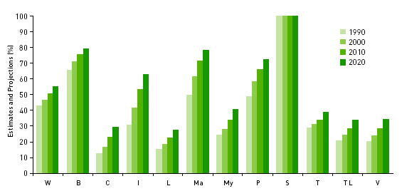
5While Southeast Asia is one of the world’s least urbanized regions, its urban population is growing at unprecedented rates, 1.75 times faster than the world’s urban population (Figure 1). Human settlements and the pressure from human activities and economic growth have expanded with urbanization. On a local basis, these factors have the potential to increase the vulnerability of ecosystems and communities to climate change. In 2008, more than 45 per cent of people in Southeast Asia lived in urban areas. By 2030, this proportion is projected to increase to 56.5 per cent (United Nations, 2004). In some countries, for example, Brunei, Indonesia, Malaysia and the Philippines, the urban proportion may rise beyond 60 per cent. Singapore is 100 per cent urbanized. In the process, villages have become towns and in some cases, mega-cities,2 expanding rapidly often without proper planning.

6Figure 1a: Southeast Asia Urbanization : Estimates and projections

Figure 1a: Southeast Asia Urbanization : Estimates and projections

Source: UN-HABITAT (2007a), p 352.

Notes: W: World, B: Brunei, C: Cambodia, I: Indonesia, L: Lao PDR, Ma: Malaysia, My: Myanmar, P: Philippines, S: Singapore, T: Thailand, TL: Timor-Leste, V: Vietnam.

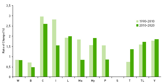
7Figure 1a: Southeast Asia Urbanization: Rate of change (%)

Figure 1a: Southeast Asia Urbanization: Rate of change (%)

Source: UN-HABITAT (2007a), p 352.

Notes: W: World, B: Brunei, C: Cambodia, I: Indonesia, L: Lao PDR, Ma: Malaysia, My: Myanmar, P: Philippines, S: Singapore, T: Thailand, TL: Timor-Leste, V: Vietnam.

8Rapid urbanization strains a municipality’s capacity to meet infrastructure and other urban service demands. Some 28 per cent (57 million) of the region’s urban population is living in slums. In some large cities such as Phnom Penh, Jakarta and Manila, it is not uncommon to find a quarter or more of the population living in informal settlements. In metro Manila, for instance, 61 per cent of its people are squatters. These informal settlements are often located in unsafe areas, which generate further risks to life, health and property, leaving them vulnerable to climate change. The region faces a range of urban environmental challenges, from rapidly expanding but poorly planned cities to forest fires, polluted air and water, inadequate water supply, sanitation and energy, deficient drains and flooding fears.

9Increasingly, as much as 80 per cent of national gross domestic product is generated within urban areas, usually through industrialization and foreign direct investment. Southeast Asia, like the rest of developing Asia, until the recent global economic slowdown, has been rapidly expanding its economy, leading to tremendous environmental changes. The economic growth pioneered in Singapore – one of 4 Asian tigers – through industrialization and increases in foreign direct investment, is now occurring in the ‘second tier’ countries of Thailand, Indonesia, Philippines, Malaysia, and more recently, Vietnam. In many cases, the industrialization-led economic growth based on the development approach of ‘grow first, clean up later’ has been synchronous with rapid urban population growth, land use change and major environmental problems, including pollution and contamination of inland and coastal waters, deforestation and overexploitation of water resources and biodiversity, eroding the region’s environmental sustainability. The United Nations Environment Program (UNEP) has ranked Jakarta, Indonesia and Bangkok, Thailand, among the world’s most polluted mega-cities.

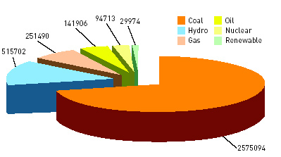
10Environmental degradation is a major challenge in the region. Institutional responsibilities for urban environmental management are often unclear and weak, especially over problems of cross-boundary pollution (UN-HABITAT, 2003; von Einsiedel, 2004). Besides weak governance, other contributing factors include economic development and new lifestyles, which have seen an explosion in the demand for private cars and energy use. Rising energy demands are currently being met by the burning of fossil fuels that pollute and generate increasing volume of greenhouse gases (GHG) emission. Energy production and consumption in Southeast Asia remain largely ‘business as usual’, generating enormous quantities of wastes into the environment. In 2006, the greater proportion, 71.4 per cent of electricity and 92.4 per cent of heat production in Southeast Asia, is from coal (Figure 2). At the same time, many people (59.2 per cent) in Southeast Asia still have no access to electricity, especially in the rural areas (International Energy Agency, 2002). Much of Cambodia, for example, has no electricity. Phnom Penh, the capital, uses about 85 per cent of the country’s electricity production, leaving the rest of the country with the remaining 15 per cent. Blackouts are a regular feature in many of its towns.

Figure 2a: Electricity Production in Southeast Asia (GWh), 2006

Figure 2a: Electricity Production in Southeast Asia (GWh), 2006

Source: International Energy Agency Statistics, http://www.iea.org/​Textbase/​stats/​electricitydata.asp.

Notes:Hydro includes production from pumped storage plants.

Figure 2b: Heat Production in Southeast Asia (TJ), 2006

Figure 2b: Heat Production in Southeast Asia (TJ), 2006

Source: International Energy Agency Statistics, http://www.iea.org/​Textbase/​stats/​electricitydata.asp.

  • 3  Data obtained from the Climate Analysis Indicators Tool of the World Resources Institute. Availabl (…)

11Southeast Asia as a whole has a low per capita emission of carbon dioxide when compared with the developed world based on medium term forecasts. Its emission by 2030 is expected to be 4.2 tons per capita compared with 6.7 in China, 10.8 in Japan, 21.9 in Australia and 23.0 in the United States (APERC, 2006). The low per capita emission is consistent with its low per capita income level. However, the per capita emission on a regional basis masks national variation. Two of its 11 countries, namely, Indonesia (0.48 per cent) and Thailand (0.24 per cent) are among the world’s top 10 countries of historical responsibility for global carbon dioxide emissions (1850-2000).3 Their emissions are comparatively small against that of the United States (29.6 per cent) and European Union (27.1 per cent). In 2002, Singapore’s per capita carbon dioxide emission was 12.2 tons and expected to reach 18.8 tons by 2030.

12Energy production and consumption in Southeast Asia are projected to produce a fourfold increase in total carbon dioxide emissions from 2002 to 2030, assuming the status quo in energy production and consumption pattern. The emission figure will be twice that of Japan, almost a third that of USA and a quarter that of China in 2030. Control of GHG emissions is crucial for Southeast Asia. Additionally, wet rice agriculture produces methane, which contributes to GHG emissions. Forest fires related to the 1997-98 El Nino event have released approximately 1.2 billion tons of carbon to the atmosphere (Van der Werf et al, 2004). According to the United Nations Environment Program, these forest fires are among the most damaging in recorded history. The loss of natural forest and tropical forest dieback will vastly increase global carbon emissions. Typically, clearance of 1 hectare of tropical forest will release about 500 m3 of carbon into the atmosphere (Jones et al, 2003).

13The region contains some of the world’s major areas of biodiversity such as the lowland rainforest of the Indo-Malayan archipelago. Forests are commonly converted to cropland, paddy and pasture to respond to growing population and urbanization needs or lost through illegal logging. Areas affected include Kalimantan and Sumatra of Indonesia, Sarawak and Sabah of Malaysia and the mountainous areas of Mekong region in Vietnam, Cambodia, Laos, Myanmar and Thailand. Indonesia, for example, has lost 60 per cent of its total forest (64 million hectares) over a period of 50 years, from 1950 to 2000, and the loss is continuing at the rate of 2 million hectares per year. Biodiversity is under threat. Hundreds of mammal and bird species have been declared threatened (UNEP, 1999). Widespread bleaching of coral reefs has been reported in Indonesia, Thailand, Cambodia and Malaysia (Preston et al, 2006). Forest under legal protection is not safe; some 56 per cent of protected lowland forest in Kalimantan, Indonesia, has been wiped out in recent years, from 1985 to 2001.

14Without effective management, rapid urban growth is expected to exacerbate existing problems of poverty, slums, pollution, water, sanitation, etc. With few exceptions, most municipalities cannot cope with the challenges of rapid urbanization. All the countries in Southeast Asia, except Singapore, are developing countries with little capacity to manage urbanization and climate impacts. Many are struggling to cope with the current climate-related hazards to which they are exposed, including cyclone, rainfall extremes, floods and droughts with severe damage and loss of life (Table 1). Take the Nargis cyclone (2 May 2008). Its winds exceeding 190 kilometers per hour swept through Myanmar’s biggest city, Yangon, for more than ten hours, flattening homes, uprooting trees, destroying power lines and creating a disaster of a scale that the country has not dealt with before. In Indonesia, some 75 to 80 percent of all natural disasters during the period of 2003-06 were linked to climatic change (The Brunei Times, 2008). Elsewhere, heavy rainfall and typhoon in 2008 have led to flooding in many Southeast Asian countries, including the Philippines, Indonesia, Lao PDR and Vietnam. In addition, scientists are predicting that climate change may trigger more frequent and violent seismic activities (Reuters, 17 Sep 2009).

Table 1: Some Major Disasters, 1980-2000, in Selected Countries

Table 1: Some Major Disasters, 1980-2000, in Selected Countries

Source: UN-HABITAT (2007a), p 369.

Notes: Aa: Annual Average, Pm: Per million

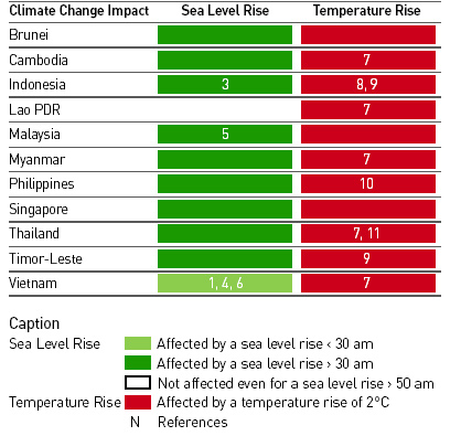
15Global climate change scenarios predict that the region’s annual temperature will increase in the order of 0.4-1.3 deg C by 2030 and 0.9-4.0 deg C by 2070 while winter rainfall is projected to decrease (less than 10 per cent by 2030 and approximately 20-30 per cent by 2070). The effect of a rise in global sea level on the region may be as much as 3-16 cm by 2030 and 7-50 cm by 2070. The region’s coastal communities would experience climate damages in the decades ahead (Table 2). Several of the Southeast Asian countries are island-states or in low-lying river deltas. The Mekong river delta of Vietnam and many small islands in Southeast Asia are most at risk. The cost for protecting Southeast Asia against sea-level rise of more than half a meter is estimated to be US$300 billion (Preston et al, 2006). According to the Asia Times, 26 May 2007, Southeast Asia is possibly one of the most vulnerable areas in the global climate-change scenarios. Extreme climate events are expected to occur more frequently. The Philippines, Vietnam, Cambodia, Lao PDR, Thailand and Indonesia are among the countries identified as climate change ‘hotspots’ (Yusuf and Francisco, 2009). They are particularly vulnerable to some of the worst manifestations of climate change expected in the coming decades.

Table 2: Estimated Impact of Climate Change to Southeast Asia

Table 2: Estimated Impact of Climate Change to Southeast Asia

Sea level rise (<30cm): 1. About 69 – 91 per cent of land area in Mekong Delta, Vietnam affected by sea-level rise during flood season (Wassmann et al, 2004).

Sea level rise (30-50cm): 2. About 29,808 km of shoreline affected in Southeast Asia with direct costs of US$226 million per year (Darwin, 2001). 3. About 34,000 km2 of land area lost in Indonesia affecting 3.1 million people (UNEP, 2006). 4. About 86 – 100 per cent of land area in Mekong Delta, Vietnam affected by sea- level rise during flood season (Wassmann et al, 2004).

Sea level rise (>50cm): 5. About 7,000 km2 of land area lost in Malaysia affecting about 500,000 people (IPCC, 2001). 6. About 40,000 km2 of land area lost in Vietnam affecting 26.9 million people (UNEP, 2006). About 15 per cent of dry land lost in Vietnam and 8 per cent of GDP (Tol, 2004).

Temperature rise (<2°C): Large-scale damages to coral reef ecosystems in the region (Hoegh-Guldberg, 1999). Coastal southeastern Asia becomes suitable for malaria transmission (Rogers and Randolph, 2000).  Epidemic potential for malaria, and dengue in Southeast Asia changes by +7 – +45 per cent, and +24 – +47 per cent, respectively (Martens et al, 1997). Temperature rise (2-4°C): About 4 – 8 per cent of species extinct in tropical woodlands and forests (global estimate) (Tol, 2004).  Population at risk for malaria in Southeast Asia declines by 1 million (van Lieshout et al, 2004).  Number of people experiencing increase in water stress in Southeast Asia increases by 0 – 10 million (Arnell, 2004). 7. Number of people experiencing increase in water stress in Greater Mekong  increases by 0 – 105 million (Arnell, 2004). 8. US$64.5 billion in cumulative health costs associated with treatment of infectious disease in Indonesia; total climate change losses equivalent to US$766 billion in Indonesia (Asia Development Bank, 1994). 9. Vegetation biomass in southern Southeast Asia (Hadley Centre, 1999). 10. Change in runoff of -12 – +7 in Lake Lanao Reservoir and -12 – +32 in Angat Reservoir, Philippines (Jose and Cruz, 1999). 11. About 1.1 – 3.5 per cent decline in Thailand’s GDP (Mendelsohn et al, 1998).

  • 4http://www.aseansec.org/21060.htm.(…)

16Climate change, major drought and flooding are refocusing attention on the environment and sustainable development. Increasingly, more initiatives have been taken, particularly post-Agenda 21 and with international aid, for example, the International Council for Local Government Initiatives (ICLEI) Cities for Climate Protection in Southeast Asia and UN-HABITAT Sustainable Cities Program to make Southeast Asian cities more sustainable. Grants (technical assistance) and loans (for example, GEF funds) are the dominant type of project funding. Many cities in Southeast Asia, including medium-sized cities such as Penang in Malaysia now have a sustainable development initiative. This is an encouraging development, especially as Roberts and Kanaley (2006, p437) pointed out, “Asia’s future is urban. It is in developing sustainable cities.” In this regard, ASEAN provides an important inter-governmental framework for regional cooperation on climate change and sustainable development. A milestone is the ASEAN Declaration on Environmental Sustainability signed by the country leaders at ASEAN 40th anniversary and 13th ASEAN Summit (Nov 2007) in Singapore. The Declaration recognizes the need to encourage the development of an ASEAN Climate Change Initiative and support the development of environmentally sustainable cities.4 In the area of climate change, the following are stated in the Declaration:

  • To work closely with the international community to better understand and adapt to the adverse impacts of climate change, including, in particular, the related issues of greenhouse gas emissions and carbon sinks;

  • To agree that the pursuit of climate change and energy security policies should avoid introducing barriers to trade and investment;

  • To intensify cooperation on the joint research, development and deployment of low emission technologies for the cleaner use of fossil fuels, recognizing that fossil fuels will continue to play a major role in our energy mix;

  • To take concrete measures to promote the use of renewable and alternative energy sources such as solar, hydro, wind, tide, biomass, bio-fuels and geothermal energy, as well as, for interested parties, civilian nuclear power, while ensuring safety and safeguards that are of current international standards, and environmental sustainability throughout the full life cycle of production and use;

  • To improve energy efficiency in key sectors of energy use through capacity building and information sharing of best practices in managing energy use and the adoption of appropriate technologies and practices;

  • To undertake effective measures towards open and competitive regional and international markets geared towards providing affordable energy at all economic levels to facilitate the adoption of energy-efficient and low-emission technologies.

17While progress is being made, especially among countries with higher income, the state of sustainable urban development and climate knowledge in Southeast Asia remains patchy. There are major differences within and across countries. The countries with relatively low adaptive capacity include the poorer countries of Cambodia and Lao PDR while Thailand, Malaysia and Vietnam are countries with relatively high adaptive capacity (Yusuf and Francisco, 2009). International development agency project/program-based activities provide an important source of initiatives. Many of these activities relate to capacity building, data gathering and policy development in specific project/program interest areas. They generally reflect specific project/program scope and are designed to improve project management and implementation rather than capacity development per se. Capacity development is absolutely essential in bringing change to Southeast Asian cities. Improving the effectiveness and cooperation between organizations in setting priorities and developing capacity that is less donor-driven and more demand responsive is needed. The knowledge gap is real.

18Of the 28 planning schools in Southeast Asia, apparently none has a teaching program on climate change. Education on planning for climate change is urgently required. Very few are undertaking research on sustainable urban development. Much of the existing climate research is oriented around technologies, for example, air quality, water and energy, such as fuel cells, bio-energy and bio-fuels. A focus on technology though common is too narrow for Southeast Asia. There are signs of change. In the face of rapid urbanization and global warming, the case for sustainable city research is strong and fast emerging as an important agenda. As Blakely (2007, p9) argues in the wider urban planning literature, “Sustainability is now firmly part of the lexicon of planning and is the best grounding for climate change research.”

19Several regional networks (for example, the Partnerships for Disaster Reduction Southeast Asia, the Asian Cities Climate Change Resilience Network) and research centers have been set up. More funding is being put into research on the environment, climate change and city including at the national level. Knowledge has become urgent as more and more Southeast Asian cities seek the development of a sustainable city for future urban living. LESTARI at the Universiti Kembangsaan Bahasa and National Hydraulic Research Institute of Malaysia (NAHRIM) Research Centre for Water Resources, Government of Malaysia, the latest regional water knowledge hub for climate change adaptation, and the National Environment Research Institute set up in 2007 at National University of Singapore, Singapore, are some examples of the new kind of interdisciplinary research institutions that are emerging in Southeast Asia to research the issues of sustainable city.

20The private sector has joined the arena. For example, Siemens Singapore in April 2009 has set up a Siemens city of the future exhibition and solutions center to profile innovative solutions and technologies for city management of future smart, safe and mobile cities.New holistic and interdisciplinary research results on Southeast Asian sustainable urban development can be expected in the years ahead as actors get into doing the interdisciplinarity and disseminate their findings. In the frontline of dynamic and unprecedented growth, urban research needs to break new ground, refocus on the interdisciplinary economic, social, technological/environmental issues of sustainable city, and seek holistic, integrated, multi-disciplinary solutions to the urban and climate challenges of Southeast Asian cities. The conventional ‘business as usual’ mode will not work; ‘business unusual’ suggests thinking outside the box—thinking, approaching, organizing and also funding sustainable urban development research in new ways.

21Even as individual countries and the regional body, ASEAN, have declared the need for improving energy efficiency, use of clean energy technologies and renewable and research, only one country, Singapore, presently seems to have more activities on climate change and lead the region in seeking more regional efforts over this issue. Singapore has started to promote climate change-related research and development after signing the Kyoto Accord in late 2006. It is master planning and developing an eco-city in China in partnership with the Chinese government. It is promoting water technology and renewable energy by investing in R&D, including the establishment of research institutes, provision of funding and test-bedding platforms to improve their performance and cost-effectiveness. It has set up an Energy Efficiency Singapore Program Office (E2PO) comprising members from the relevant government and research institutions. E2PO has developed a national plan to promote energy efficiency, comprising actions in several areas:

  • Promoting the adoption of energy efficient technology and measures by addressing the market barriers to energy efficiency;

  • Raising awareness to reach out to the public and businesses so as to stimulate energy efficient behavior and practices;

  • Building capability to drive and sustain energy efficiency efforts and to develop the local knowledge base and expertise in energy management;

  • Promoting research and development to enhance Singapore’s capability in energy efficient technologies.

22Energy production is a major consideration. Several other countries have also started to converge on renewable energy. Malaysia, the Philippines and Thailand have all established renewable energy strategies and targets. Malaysia, for example, has a Five Fuel Diversification Policy since 2000, a small renewable energy power program, Biogen program with a target (2005) of 5 per cent or 500 mw of power capacity. The Philippines renewable energy policy framework 2003 includes a target (2003-2013) of 100 per cent increase of renewable energy power capacity while Thailand’s strategic plan for renewable energy development 2003 sets a target by 2011 of 9 per cent renewable energy share in primary energy and 4 per cent renewable energy power capacity.

23Energy efficiency policy in Thailand appears one of the most advanced in ASEAN. The driver is the Thai government’s vision to establish Thailand as the Regional Energy Centre for Southeast Asia. It has implemented a Strategic Plan for Renewable Energy Development. Solar, wind, biomass, biogas, hydro, bio-fuels, geothermal and fuel cells are included in the Strategic Plan as well as energy efficiency (Australian Business Council for Sustainable Energy,2005). Its Department of Energy Development and Promotion and Energy Policy Office are pursuing activities such as consumer education, industrial energy audits, thermal/electricity energy efficiency demonstration projects and end-use studies. In the Philippines, integrating GHG emission reduction and avoidance strategies into the city’s operations of waste management, land use planning, transport improvement and building retrofits such as in the Cagayan de Oro, Philippines ICLEI project could serve as a promising practice for other cities (ICLEI, 2009). Cagayan de Oro is greening its energy supply and making demand-side improvements with the target to reduce GHG emissions by 10 per cent against forecasted emissions growth.

24There are increasing efforts, both commercially and promoted by government, to develop and expand bio-fuel production; bio-diesel from palm oil is especially favored. Although bio-fuel is often pitched as a sustainable energy source, there is concern that the rush to develop it may result in more destruction of old forests to clear the way for oil-palm plantations, contributing to the problem of slash and burn as well as resultant haze pollution in adjoining urban areas. There is also a regional shift towards more natural gas, which is desirable in terms of its lower carbon-dioxide emissions. By 2006, 78 per cent of Singapore’s electricity was generated by natural gas using highly efficient combined cycled technology, one of the most advanced in the world. But, natural gas has its obstacles, including delays in constructing pipelines and issue with upstream production, which often releases carbon dioxide unless engineering measures are taken to re-inject the gas.

25More hydropower is likely to be used, especially in the Mekong region. But, again there are environmental concerns as to the impact of the river damming on downstream river life and communities vulnerable to drought. Vietnam, in particular, is finding this a major problem, with its exceptionally dry seasons during the past two to three years, leading to low water levels in the reservoirs behind hydro-dams and competition in supply for farmers down river for rice irrigation and for power generation. Nuclear power has also emerged as a serious possibility in several countries, including Vietnam, Indonesia, Thailand and Myanmar. Again, there are many issues here, ranging from economic feasibility to safety and weapons-proliferation concerns that require research and policy development to address. Policies and mechanisms conducive to knowledge dissemination and technology transfer among countries including between advanced developed countries and Southeast Asia are clearly required.

Urban Planning revisited

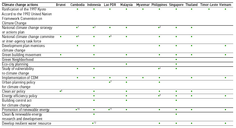
26Even though global climate change awareness has been around for some time, it is only in recent years that cities and urban planners in the region appear to consider the environment in their planning of competitive and livable cities. Many countries have begun to address climate change issues in different ministries. Some have formulated national climate change policy with measures for adaptation and mitigation (see Table 3). Increasingly, environmental sustainability is mentioned in development plans. In 2008, ASEAN presented the first ASEAN Environmentally Sustainable City award to 10 cities/townships/districts in ASEAN that have made exemplary effort towards environmental sustainability. These 10 cities are: Brunei Darussalam: Temburong District, Cambodia: Municipality of Phnom Penh, Indonesia: Palembang City, Lao PDR: Luang Prabang District, Malaysia: North Kuching City Hall, Myanmar: Taungyi City, Philippines: Puerto Princesa City, Singapore: South West Community Development Council, Thailand: Bangkok City, Vietnam: Ha Long City. By and large, climate change is not mainstreamed in development plans.

Table 5 – Climate Change Actions

Table 5 - Climate Change Actions

Notes:

1. The Ministry of Environment (2001) has developed the National Action Plan on Climate Change. In August 2003, CCCO started implementation of a new project, the National Adaptation Program of Action to Climate Change with financial support from GEF through UNDP.

2. Indonesia released the National Action Plan for Climate Change Mitigation and Adaptation at the end of 2007. The document still demands revision by related sectors, academics and experts. See The Brunei Times, 10 July 2008http://www.bt.com.bn/​en/​opinion/​2008/​07/​10/​tackling_climate_change_the_finest_way.

3. Funded by USAID.

4. The Ministry of Environment has set up a separate office called Cambodia Climate Change Office (CCCO) in June 2003.

5.  Science, Technology and Environment Agency has a key role to coordinate across all ministries and local authorities to manage the overall environment throughout Lao PDR.

6. An ADB climate change project in 1991 assessed Philippines’ vulnerable sectors and areas to climate change including agriculture, water resources and coastal areas.

7. Pragmatic integratedtransport plans for the main urban centre and the formulation of an overall urban transport policy including the possibility of mass public transport are high priority of Lao PDR government facing rapidly increasing volumes of motorized traffic in urbancenters.

8. Brunei has national programs include improvements of transportation infrastructure to reduce traffic congestion, cogeneration power station to reduce emissions of pollutant gases, and full use of unleaded gasoline to reduce air pollution. http://www.wpro.who.int/​NR/​rdonlyres/​64F00DEF-F568-4A03-8855-13C2958D0B4B/​0/​BRU.pdf.

9. Energy efficiency programs in the Philippines are directed by the Department of Energy and guided by an Energy Plan that currently covers the period from 2002 to 2011. See Renewable Energy and Energy Efficiency Partnership http://www.reeep.org/​index.php?id=9353&text=policy-db&special=viewitem&cid=72.

10. Renewable Electricity Action Plan 2002–2012. See Renewable Energy and Energy Efficiency Partnership http://www.reeep.org/​index.php?id=9353&text=policy-database&special=viewitem&cid=30.

11. A World Bank-assisted project in 1997 has demonstrated renewable energy technologies as off-grid electrification options to reduce inefficient use of fossil fuels in diesel generators in rural areas.

12. Solar energy desalination project in North Jakarta district.

Source: Country, city council, renewable energy and green buildings movement websites.

27Mainstreaming of climate change in development planning is critical. UN-HABITAT (2007b) has reiterated that urban planning is important in managing climate change because well-planned cities provide a better foundation for sustainable development than unplanned cities. Both adaptation and mitigation actions of environmental change require urban planning. Among others, urban planning and development control could help to mitigate the urban heat island effect by creating open spaces and parks as heat sinks in urban areas, reduce the urban ecological footprint by planning for more efficient, compact and mixed use city forms and a shift to public transport-based movement. In the urban and planning literature, there is a gradual shift of focus on mitigation actions to a concern with longer term adaptation measures of, for example, preventing flooding and landslides, protecting or relocating vulnerable settlements, improving drainage and preventing new developments in areas likely to be affected by sea level rise or floods, among others. The integrative planning of a future climate regime has significant implications for Southeast Asian urbanization, especially in mega-cities and vulnerable areas. Raising the policy profile of climate change within the context of sustainable development is crucial in realizing the vision of a sustainable Southeast Asia.

28Land use change has impact on the carbon balance of ecosystems. Practices that detract from environmental sustainability cannot be promoted. At its simplest, the common planning typology of land use zoning determines land cover types. Land cover types affect energy and water consumption as well as waste and traffic production and GHG emissions (Pauleit and Duhme, 2000). In many developing countries, local authorities lack the mandate and human capacity to handle urban planning and its enforcement mechanisms. As the Asian Development Bank (2008) concluded in its review of managing Asian cities, capacities are deficient in key areas of urban management, economic and social planning and environmental management in many Asian cities, Southeast Asian cities included. The comparative newness and unprecedented scale of urbanization has accentuated the problem. Improved technical competence in urban planning is required at all levels of government.

29Beyond the demand for professional urban planning education, most developing countries in the region are facing the problem of weak capacity of local or municipal government.Visions are lacking. Planning is generally short-term, physically oriented and unable to respond effectively to change. Newer and more innovative planning approaches are in order. There is also the issue of plan implementation. Plans that reflect sustainable development principles carry no meaning if they are not implemented. There is an urgent need to strengthen the institutional capabilities that are prerequisite to effective plan implementation. More attention has to be given to the functioning of the planning system and as such, to legislation, regulations and processes that are out of date or are insufficiently reformed to be able to deal with the major challenges of the 21st century. Strong government leadership is indispensable, particularly where there is a need to create inclusive policy conditions and a multi-stakeholder process for plan implementation. Proper modalities should also be developed to monitor plan implementation and ensure its continued relevance to changing conditions and dynamics.

30Well-planned cities are not only efficient but also make sustainable use of resources including space, energy and water. Take Singapore. The strong state commitment to planning has transformed the city from ‘third world to first world’ (Lee, 2000; Yuen 2004). Its comprehensive, strategic, integrated urban development planning has led to the efficient use of space, clustering many people in a relatively smaller land area, often through high-rise high-density settlements. Research has indicated that denser urban areas emit less radiant heat energy per parcel than do more expansive developed areas (Stone and Rodgers, 2001). The co-location of high-rise, high-density urban form, services and employment is purposefully designed to configure a hierarchy and location of community facilities that reduce or minimize travel by private car and enhance walking and usage of public transportation while enhancing quality of life. Its deliberate greening policy at the building, neighborhood and city levels gives careful consideration to the relationship between the built and natural environments, creating a garden city and increasing the cooling potential of its built-up areas. Additionally, since 2007, green buildings have been encouraged. These buildings adopt various energy efficiency ways and designs to minimize impact on climate change, including the use of recycled or recyclable materials for construction.

31Singapore is building its first eco-friendly precinct of 700 public housing flats, expected to complete by 2011, to promote sustainable green living. There will be more greenery provision, which is expected to lower the surrounding temperature by as much as 4 deg C. Solar panels on the roof of buildings will power the common corridors, improving energy resource utilization and saving 80 percent of the energy used. On the industrial front, it has built an industrial park on Jurong Island planned on the principle of industrial symbiosis where the waste or by-product of one enterprise becomes the resource or input of another. While Singapore may have its unique characteristics, its strong commitment to planning bears testimony to planning in action. In the era of climate change, cities must be planned to develop sustainably from the start. However, planning is not static. The environmental dimension of urban planning is increasingly also about enabling and adapting cities to meet the dynamics of climate change.

32More than ever, sustainable urban development is now the key theme of urban planning and is fundamental for climate change policy. Energy efficient buildings and built form, renewable energy sources, climate responsive design and standards together with open space and green areas are important to ensure a sustainable neighborhood.
Cities can take proactive measures to reduce emissions from vehicles.  Motor vehicles – a major source of carbon dioxide emissions – are set to increase in Southeast Asian cities. In per capita terms, car ownership is still low. But, in large urban areas, growing car ownership continues to congest cities, pollute the atmosphere and endanger community health through vehicle exhaust. Alternative urban form aside, better public-transport systems from buses to rail and sustainable transport options are clearly critical. Bangkok, Thailand, long notorious for traffic jams and air pollution, is now benefiting from its light rail and underground rail system as well as stricter standards and controls on gasoline quality. In a similar vein, there are plans for mass-transit systems for the large and fast-growing cities of Hanoi and Ho Chi Minh in Vietnam, the fastest-growing economy in the region.

33Urban planning, though essential is not sufficient, in addressing climate change. Population, economic development, technology advancement and government policies on energy and environment are key drivers of GHG emissions and interlinked in a complex web of interactions. Energy production and use, for example, are sensitive to changes in the climate. The climate change effects on energy supply and demand will depend not only on climatic factors but also on the patterns of economic growth, land use, population growth and distribution, technological change and social and cultural trends that shape individual and institutional actions.Understanding these major driving forces will enable the setting of corresponding adaptation strategies and policies to overcome entrenched lifestyle preferences that significantly contribute to climate change. To succeed, climate proofing requires concerted action across all sectors. This includes cooperation and joint programming on population, economic growth, GHG emissions control, R&D, application of clean technologies, renewable energy and eco-city policies to ameliorate GHG emissions, among others.

34Collaboration across planning, enforcement and compliance regimes can strengthen the integration of environmental concerns into the wider development agenda. As demonstrated by the Singapore experience, the government plays a critical role in the coordination approach and creating policies, incentives and disincentives and plans that encourage sustainable urban development, in environmental education and training, and enforcement of policies and regulations. To improve the resilience of Southeast Asian cities to climate change, it is imperative to also implement institutional strengthening and capacity building to ensure that the institutions and human capital have the knowledge on climate change and are able to make effective decision, allocate resources and manage risk and implementation.

Conclusion

35The challenge of climate change in Southeast Asia is real and urgent. Climate change is likely to amplify some of the existing urban and environmental stresses and vulnerabilities of its urban communities, many of which are living in coastal and low-lying areas and rapidly expanding mega-cities. A business-as-usual scenario is unlikely to support a sustainable Southeast Asia. Measured against this situation, Southeast Asian responses to date have been largely inadequate even though several important steps have been taken and a number of essential foundations, both at country and regional levels, have been established for further action. For example, ASEAN leaders have recently signed the Declaration on Environmental Sustainability and the ASEAN cooperation in environment has established a common agenda and forged consensus on some policy goals for sustainable development as well as action to address trans-boundary haze pollution, nature conservation and biodiversity, marine and coastal environment problems. Another milestone is the establishment of the ASEAN sub-regional climate review meeting in 2000 to closely monitor the weather condition especially during the dry seasons to prevent and mitigate the damages from recurrent fires and haze. Yet, its urban land, forests and rivers remain environmentally vulnerable.

36While there is no standard model solution and sustainable development may be more complicated than the commonly acknowledged economic, social and environmental dimensions in practice, the importance of sustainable development as the guiding principle to climate proofing cannot be neglected. The mainstreaming of climate issues into national strategies and development planning is crucial. In all cases, urban planning offers an important entry point, shaping urban form in very particular ways with implications on climate change. The proactive development of newer and innovative planning is essential for better environmental management and sustainable development in this vein. The emergence of urban planning’s central role has reinforced the need for truly cross-sectoral integration to be in place as well as capacity development so as not to overburden the already weak implementation capacity.

BIBLIOGRAPHY

Arnell N. (2004). “Climate change and global water resources: SRES emissions and socioeconomic scenarios.”  Global Environmental Change, 14, 31-52.

Asian Development Bank (ADB) (1994). Climate Change in Asia: Executive Summary, Manila, ADB.

Asian Development Bank (ADB) (2008). Managing Asian Cities, Manila, ADB.

Asia-Pacific Energy Research Centre (APERC) (2006). APERC Energy Demand and Supply Outlook 2006.

Australian Business Council for Sustainable Energy (2005).Renewable Energy in Asia: The Thailand Report, August.

Blakely E. J. (2007). “Urban planning for climate change.” Lincoln Institute of Land Policy Working Paper.

Darwin R. F. & Tol R. (2001). “Estimates of the economic effects of sea-level rise.”Environmental and Resource Economics, 19, 113-129.

Hadley Centre (1999). “Climate change and its impacts: stabilisation of CO2 in the atmosphere.” Hadley Centre for Climate Prediction and Research, Met Office, UK,http://www.met-office.gov.uk/research/hadleycentre/pubs/brochures/B1999/climate_web.pdf

Hoegh-Guldberg O. (1999). “Climate change, coral bleaching and the future of the world’s coral reefs.” Marine and Freshwater Ecology, 50, 839-866.

ICLEI (2009). International Council for Local Environmental Initiatives: Cities for Climate Protection in Southeast Asia,http://www.epa.gov/usctcgat/file/toolmanager/O86C299F62935.pdf

International Energy Agency (2002). World Energy Outlook 2002, IEA/OECD, Paris.

IPCC (2001). Climate Change 2001: Impacts, Adaptation and Vulnerability. McCarthy J. et al. (editors) Contribution of Working Group II to the Third Assessment Report of the Intergovernmental Panel on Climate Change, World Meteorological Organisation and United Nations Environment Programme. Cambridge University Press.

Jones G. W. (2002). “Southeast Asian urbanization and the growth of mega-urban regions.” Journal of Population Research, 19(2), 119-136.

Jones C. D., et al.(2003). “Strong carbon cycle feedbacks CO2 and sulphate aerosols.” Geophysical Research Letters, 30, doi:10.1029/2003GL01686.

Jose  A. M. & Cruz N. A. (1999). “Climate change impacts and responses in the Philippines: Water Resources.” Climate Research, 12, 77-84.

Lee K. Y. (2000). From Third World to First: The Singapore Story, 1965-2000. New York: HarperCollins.

Martens W. J. M., Jetten T. H.,  & Focks A. D. (1997). “Sensitivity of malaria, schistosomiasis and dengue to global warming.” Climatic Change, 35, 145-156.

Mendelsohn R., Morrison W., Schlesinger M. E., and Andronova N. E. (1998). “Country- specific market impacts of climate change.” Proc., IPCC Asia-Pacific Workshop on Integrated Assessment Models, 10-12 March, 1997, Tokyo, Japan.http://crga.atmos.uiuc.edu/publications/market_impact/MarktImp.PDF#search=%22Country-specific%20market%20impacts%20of%20climate%20change%22

Pauleit S. & Duhme F. (2000). “Assessing the environmental performance of land cover types for urban planning.” Landscape and Urban Planning, 52(1), 1-20.

Preston L. B. et al. (2006). Climate Change in the Asia/Pacific Region, Consultancy Report Prepared for the Climate Change and Development Roundtable, CSIRO Marine and Atmospheric Research.

Roberts, B. & Kanaley, T. (2006). Urbanisation and Sustainability in Asia, Manila: ADB.

Rogers D. J. &  Randolph S. E. (2000). “The global spread of malaria in a future warmer world.” Science,289, 1763-1766.

Stone J. B. & Rodgers M. O. (2001).  “Urban form and thermal efficiency: How the design of cities influences the urban heat island effect.” Journal of the American Planning Association,  Spring, 186-198.

The Brunei Times (2008). from the country report presented by the Department of Public Works of Indonesia during the COP Conference of 13 Parties in Bali in November 2007,http://www.bt.com.bn/en/opinion/2008/07/10/tackling_climate_change_the_finest_way

Tol R. S. J. (2004). “The Double Trade-Off Between Adaptation and Mitigation for Sea-Level Rise: An Application of FUND.” Working Paper FNU-48, Research Unit Sustainability and Global Change, Hamburg University and Centre for Marine and Atmospheric Sciences, Hamburg, Germany,http://www.uni-hamburg.de/Wiss/FB/15/Sustainability/slradaptmitigatewp.pdf

UNEP (1999). Global Environment Outlook 2000. London: Earthscan.

UNEP (2006). Geo Year Book 2006: An Overview of Our Changing Environment.  Early Warning and Assessment, United Nations Environment Programme, Nairobi, Kenya,http://www.unep.org/geo/yearbook/yb2006/PDF/Complete_pdf_GYB_2006.pdf

United Nations (2004). World Urbanization Prospects: The 2003 Revision, United Nations, Department of Economic and Social Affairs, New York.

UN-HABITAT (2003). Water and Sanitation in the World’s Cities: Local Action for Global Goals, London: Earthscan.

UN-HABITAT (2007a). Enhancing Urban Safety and Security: Global Report on Human Settlements 2007, London: Earthscan.

UN-HABITAT (2007b). UN-HABITAT pitches for urban planning, Bonn,http://www.unhabitat.org/content.asp?cid=4836&catid=550&typeid=6&subMenuId=0

Van der Werf G. R. et al.(2004). “Continental-scale partitioning of fire emissions during the 1997 to 2001 El Niño/La Niña period.” Science, 303, 73-76.

Van Lieshout M. et al.(2004). “Climate change and malaria: Analysis of the SRES climate and socio-economic scenarios.” Global Environmental Change, 14, 87-99.

Von Einsiedel N. (2004). “Strengthening local government capacities in urban planning and finance: Lessons from the East Asian city development strategies,” in Freire, M., and Yuen, B., editors, Enhancing Urban Management in East Asia, Ashgate: Aldershot, p 159-169.

Wassmann R., et al. (2004). “Sea level rise affecting the Vietnamese Mekong Delta: Water elevation in the flood season and implications for rice production.” Climatic Change, 66, 89-107.

Williamson L. (2007). BBC News, 2 May 2007, http://news.bbc.co.uk/2/hi/asia-pacific/6610973.stm

Yuen B. (2004). “Planning Singapore growth for better living” in Freire M., and Yuen B., editors, Enhancing Urban Management in East Asia, Ashgate: Aldershot, p 55-70.

Yusuf A. A. & Francisco, H. (2009). Climate Change Vulnerability Mapping for Southeast Asia, IDRC.

NOTES

1  ASEAN was established on 8 August 1967 in Bangkok by the five original Member Countries, namely, Indonesia, Malaysia, Philippines, Singapore, and Thailand.  Brunei Darussalam joined on 8 January 1984, Vietnam on 28 July 1995, Lao PDR and Myanmar on 23 July 1997, and Cambodia on 30 April 1999.

2  Jones (2002) has estimated that 11 per cent of Southeast Asian population lives in mega-urban regions. The population of Greater Jakarta, Manila and Bangkok each exceeds 10 million and growing.

3  Data obtained from the Climate Analysis Indicators Tool of the World Resources Institute. Available at: http://cait.wri.org/.

4 http://www.aseansec.org/21060.htm.

LIST OF ILLUSTRATIONS

Title Figure 1a: Southeast Asia Urbanization : Estimates and projections
Credits Source: UN-HABITAT (2007a), p 352.
URL http://sapiens.revues.org/docannexe/image/881/img-1.jpg
File image/jpeg, 44k
Title Figure 1a: Southeast Asia Urbanization: Rate of change (%)
Credits Source: UN-HABITAT (2007a), p 352.
URL http://sapiens.revues.org/docannexe/image/881/img-2.jpg
File image/jpeg, 28k
Title Figure 2a: Electricity Production in Southeast Asia (GWh), 2006
Credits Source: International Energy Agency Statistics, http://www.iea.org/​Textbase/​stats/​electricitydata.asp.
URL http://sapiens.revues.org/docannexe/image/881/img-3.jpg
File image/jpeg, 28k
Title Figure 2b: Heat Production in Southeast Asia (TJ), 2006
Credits Source: International Energy Agency Statistics, http://www.iea.org/​Textbase/​stats/​electricitydata.asp.
URL http://sapiens.revues.org/docannexe/image/881/img-4.jpg
File image/jpeg, 24k
Title Table 1: Some Major Disasters, 1980-2000, in Selected Countries
Caption Source: UN-HABITAT (2007a), p 369.
URL http://sapiens.revues.org/docannexe/image/881/img-5.jpg
File image/jpeg, 60k
Title Table 2: Estimated Impact of Climate Change to Southeast Asia
Caption Sea level rise (<30cm): 1. About 69 – 91 per cent of land area in Mekong Delta, Vietnam affected by sea-level rise during flood season (Wassmann et al, 2004).
URL http://sapiens.revues.org/docannexe/image/881/img-6.jpg
File image/jpeg, 64k
Title Table 5 – Climate Change Actions
Caption Notes:
URL http://sapiens.revues.org/docannexe/image/881/img-7.jpg
File image/jpeg, 92k

TO QUOTE THIS DOCUMENT

Electronic reference

Belinda Yuen and Leon Kong, « Climate Change and Urban Planning in Southeast Asia », S.A.P.I.EN.S [Online], 2.3 | 2009, Online since 18 December 2009, Connection on 04 November 2012. URL : http://sapiens.revues.org/881

AUTHORS

Belinda Yuen

National University of Singapore,

email: rstbyuen@nus.edu.sg

Leon Kong

AKO Knowledge Solutions,

email: ksquarel@gmail.com

COPYRIGHT

Licence Creative Commons

Protecting the City, Before Next Time

Source: NYTimes

Architecture Research Office and dlandstudio

URBAN WETLANDS A rendering of Lower Manhattan that shows tidal marshes to absorb waves.

By 
Published: November 3, 2012 Arriving in Venice years ago, Robert Benchley, the New York journalist and wit, is said to have sent a mock-panicked telegram to his editor: “Streets flooded. Please advise.”

Related in Opinion

Related in Opinion
ROOM FOR DEBATE

Should New York Build Sea Gates?

How can we better protect New York City from flooding?

After the enormous storm last week, which genuinely panicked New York with its staggering and often fatal violence, residents here could certainly identify with the first line of Benchley’s note. But what about the second?

If, as climate experts say, sea levels in the region have not only gradually increased, but are also likely to get higher as time goes by, then the question is: What is the way forward? Does the city continue to build ever-sturdier and ever-higher sea walls? Or does it accept the uncomfortable idea that parts of New York will occasionally flood and that the smarter method is to make the local infrastructure more elastic and better able to recover?

Gov. Andrew M. Cuomo on Wednesday gave a sea wall the nod. Because of the recent history of powerful storms hitting the area, he said, elected officials have a responsibility to consider new and innovative plans to prevent similar damage in the future. “Climate change is a reality,” Mr. Cuomo said. “Given the frequency of these extreme weather situations we have had, for us to sit here today and say this is once in a generation and it’s not going to happen again, I think would be shortsighted.”

The water rose in Dumbo, Brooklyn, on Monday.
Kirsten Luce for The New York Times

The water rose in Dumbo, Brooklyn, on Monday.

But some experts in the field who have thought deeply about how to protect New York from huge storms like Hurricane Sandy — and especially from the coastal surges they produce — suggested that less intrusive forms of so-called soft infrastructure might prove more effective in sheltering the city than mammoth Venetian sea walls. Mayor Michael R. Bloomberg seemed to agree with them on Thursday when he said: “I don’t think there’s any practical way to build barriers in the oceans. Even if you spent a fortune, it’s not clear to me that you would get much value for it.”

According to the experts — architects, environmentalists and civil engineers — large-scale projects like underwater gates are expensive, cumbersome and difficult to build. More important, they say, such undertakings are binary projects that work just fine until the moment they do not.

Whatever the way forward, Klaus H. Jacob, a Columbia University seismologist and an expert on urban environmental disasters, said the century-event of Hurricane Sandy could become, because of rising seas alone, an annual occurrence by 2100.

“We know what we have to do,” said Dr. Jacob, who predicted last week’s tragedy with eerily prescient detail in a 2011 report. “The question is when do we get beyond talking and get to action.”

Among those actions already proposed are relatively minor alterations to the building code, to ban housing boilers and electrical systems in basements, and slightly more apocalyptic strategies, like one known as managed retreat, in which people would cede low-lying areas to the sea. While no one is calling for a mass and permanent exodus from the Rockaways, for instance, some experts, like Radley Horton, a climatologist at Columbia University, said that as parts of New York became more difficult — and costly — to protect, managed retreat needed at least to become “part of the public discussion.”

Here, then, are three proposals — some traditional, some fantastic, but all at least theoretically workable — designed to reduce the effects of storms like Hurricane Sandy on three especially vulnerable New York neighborhoods: Lower Manhattan, the Red Hook and Gowanus sections of Brooklyn, and the northern shore of Staten Island.

Lower Manhattan

Marshy Edges, Absorptive Streets

Picture a fringe of mossy wetlands strapped like a beard to Lower Manhattan’s chin, and you are halfway toward imagining the plan to protect the financial district and its environs dreamed up by the architect Stephen Cassell and a team from his firm, Architecture Research Office, and a partner firm, dlandstudio.

“Our goal was to design a more resilient city,” Mr. Cassell said. “We may not always be able to keep the water out, so we wanted to improve the edges and the streets of the city to deal with flooding in a more robust way.”

Among the most disturbing images to emerge from the aftermath of the storm was that of a pile of cars floating upended in the waters of a parking lot near Wall Street. Lower Manhattan, where most of the borough’s power failures occurred, is vulnerable to floods like this not just because it sits low in relation to the sea; it also juts out on heaps of artificial landfill, into the fickle waters of New York Harbor. It is probably not coincidental that the flooded areas of Manhattan, largely correspond to the island’s prelandfill borders.

To prevent incursions by water, Mr. Cassell and his planners imagined ringing Lower Manhattan with a grassy network of land-based parks accompanied by watery patches of wetlands and tidal salt marshes. At Battery Park, for instance, the marshes would weave through a series of breakwater islands made of geo-textile tubes and covered with marine plantings. On the Lower East Side of the island, Mr. Cassell and his team envisioned extending Manhattan by a block or two — with additional landfill — to create space for another new park and a salt marsh.

Beyond serving as recreation areas, these engineered green spaces would sop up and reduce the force of incoming water.

“When there’s a storm surge, it creates an enormous amount of energy,” Mr. Cassell said. “Wetlands absorb that energy and protect the coastline.”

As a complement to the parks and marshes, Mr. Cassell’s team would re-engineer the streets in the neighborhood to make the area better able to handle surging waves, creating three variations of roadway. On so-called Level 1 streets, asphalt would be replaced with absorptive materials, like porous concrete, to soak up excess water like a sponge and to irrigate plantings in the street bed. Level 2 streets, planned for stronger surges, would send running water into the marshes at the island’s edges and also into prepositioned ponds meant to collect runoff for dry spells. Level 3 streets — the only ones that might require a shift in the current city grid — would be parallel to the shoreline and designed to drain surging water back into the harbor.

“We weren’t fully going back to nature with our plan,” Mr. Cassell said. “We thought of it more as engineered ecology. But if you look at the history of Manhattan, we have pushed nature off the island and replaced it with man-made infrastructure. What we can do is start to reintegrate things and make the city more durable.”

Red Hook and Gowanus

Oysters to the Rescue

The architect and landscape designer Kate Orff based her plan to shield the Red Hook and Gowanus neighborhoods of Brooklyn on the outsize powers of the oyster. “The era of big infrastructure is over,” Ms. Orff said. By placing her faith in a palm-size bivalve to reduce the effects of surging storms, Ms. Orff said, she is “blending urbanism and ecology” and also “looking to the past to reimagine the future.”

Red Hook, Brooklyn, was hit hard last week by flooding from Hurricane Sandy.
Spencer Platt/Getty Images

Red Hook, Brooklyn, was hit hard last week by flooding from Hurricane Sandy.

Red Hook, in particular, was thrashed by Hurricane Sandy as some of the local inlets, like the Buttermilk Channel and Gowanus Bay, spilled into the low-lying area, swamping public housing projects and sending water rushing so high through the streets it occasionally swallowed up cars and bicycles.

Ms. Orff’s proposal., created by a team at her design firm Scape/Landscape Architecture P.L.L.C., envisions a system of artificial reefs in the channel and the bay built out of rocks, shells and fuzzy rope that is intended to nurture the growth of oysters (she calls them “nature’s wave attenuators”).

<strong>WATERWORLD</strong>&nbsp;A reef constructed from rock and shell piles to host oyster growth, as seen in a rendering for a proposal in Brooklyn. Such a structure could filter water and mitigate storm surge.
Scape/Landscape Architecture

WATERWORLD A reef constructed from rock and shell piles to host oyster growth, as seen in a rendering for a proposal in Brooklyn. Such a structure could filter water and mitigate storm surge.


The Bay Ridge Flats, a stretch of water that sits off the coast of the Brooklyn Army Terminal, was once home to a small archipelago of islands that protected the Brooklyn coastline. The islands have long since disappeared because of dredging, and Ms. Orff would replace them with her oyster-studded barriers, which, over time, would form a sort of “ecological glue” and mitigate onrushing tides, she said.

<strong>AQUACULTURE</strong> Oyster beds as depicted in a rendering for a proposal in Gowanus, Brooklyn. The shellfish could be cultivated by community groups and seeded on a planned reef, part of a water filtration and surge-mitigating system.
Scape/Landscape Architecture

AQUACULTURE Oyster beds as depicted in a rendering for a proposal in Gowanus, Brooklyn. The shellfish could be cultivated by community groups and seeded on a planned reef, part of a water filtration and surge-mitigating system.


At the same time, she imagines installing oyster beds along the banks of the Gowanus Canal in a series of what are known as Floating Upweller Systems (Flupsys) — essentially, artificial shellfish nurseries. A powerful fan blows aerated water through a group of eight chambers in which oysters or mussels can be grown. The chambers protect the budding oysters from predators like starfish. Above the Flupsys, Ms. Orff would place a public walkway for joggers and strollers, punctured every so often by hatches that could be lifted to permit a view of the nature below.

“This is infrastructure that we can do now,” she explained. “It’s not something we have to think about and fund with billions of dollars 50 years down the road.”

Oysters have the added benefit of acting as natural water filters — a single one can clean up to 50 gallons of water a day. By being placed in the Gowanus Canal, Ms. Orff hopes, they could further purify what has already been named a federal Superfund site. She wants, by way of her project, to change how we think about infrastructure projects.

“Infrastructure isn’t separate from us, or it shouldn’t be,” Ms. Orff said. “It’s among us, it’s next to us, embedded in our cities and our public spaces.”

Staten Island

A Bridge in Troubled Waters

A rendering of a storm barrier with a drawbridge on Arthur Kill, intended to protect Staten Island in a Category 3 hurricane.
CDM Smith, Inc

A rendering of a storm barrier with a drawbridge on Arthur Kill, intended to protect Staten Island in a Category 3 hurricane.


A few years ago, Lawrence J. Murphy, an engineer in the New York office of the global engineering firm CDM Smith, was asked by the local chapter of the American Society of Civil Engineers to propose a way of protecting northern Staten Island from the forces of a Category 3 hurricane. He came up with a plan to build a classic storm-surge barrier across the Arthur Kill, the tidal strait that separates Staten Island from the mainland of New Jersey, designed to act in concert with similar barriers in the East River, the Narrows and the waters near the Rockaway Peninsula.

Staten Island was ravaged by Hurricane Sandy, as entire neighborhoods were flooded, a168-foot water tanker crashed onshore and city officials said that most of the fatalities in the city occurred there. It is arguably New York’s most exposed borough, surrounded not by peaceful rivers but by oceanic channels like the Arthur Kill and, of course, the Atlantic itself.

Mr. Murphy’s concept, created with his partner, Thomas Schoettle, calls for the construction of a damlike structure with suspension towers spanning the Arthur Kill. Tidal gates below the surface would open and close as needed.

A rescue from Dongan Hills, Staten Island, on Tuesday.
Michael Kirby Smith for The New York Times

A rescue from Dongan Hills, Staten Island, on Tuesday.


According to the Army Corps of Engineers, Category 3 hurricanes (Hurricane Sandy was a Category 1 storm, downgraded by the time it reached New York) would produce surges of slightly more than 14 feet above normal sea levels. Mr. Murphy designed his barrier to protect against “overtopping waves” of an additional 8 feet, for a total height of 22 feet. He also designed a complex system of locks and drawbridges to accommodate the numerous commercial ships that navigate the kill.

Mr. Murphy’s barrier would be run by a trained staff and would operate on emergency power in the event of an electrical failure. Because strong tides pass through the kill, he would also outfit the barrier with tidal generators, which, as an extra benefit, could produce electricity.

Nor did Mr. Murphy ignore the possibilities of public recreation. “The concept design of the Arthur Kill Storm Barrier has been made with a focus on aesthetics to create a destination,” he wrote in his proposal. “The multiuse path can provide bicycling and walking opportunities. Fishing and bird-watching amenities can also be provided.”

A version of this article appeared in print on November 4, 2012, on page MB1 of the New York edition with the headline: Protecting the City, Before Next Time.